When a City Loses Its Natural Drainage
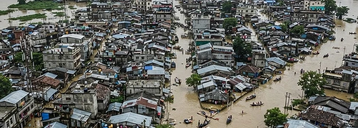
Guwahati floods from its hills as well as its river. The city was built over the drainage it depended on.
Documented facts
Land-use research documents substantial conversion of Guwahati's hillslopes and wetlands to built-up area since 2001 (published urban land-use studies).
Documented evidenceDeepor Beel, designated a Ramsar wetland in 2002, lies within Guwahati's hydrological setting and receives urban runoff (Ramsar information sheet).
Documented evidenceAssam State Disaster Management Authority reports urban flooding in Guwahati during most monsoon seasons (ASDMA situation reports).
Documented evidence
Timeline
- January 1, 1986Environment (Protection) Act establishes the umbrella environmental framework.Documented evidence
- June 19, 2002Deepor Beel designated a Ramsar site.Documented evidence
- September 26, 2017Wetlands (Conservation and Management) Rules notified.Documented evidence
Geographical context
Guwahati occupies a bowl between the Shillong plateau's foothills and the Brahmaputra. Water arriving from the hills west of the city historically drained into Deepor Beel, a wetland on the city's edge that is also a Ramsar site of international importance. The wetland still receives urban water, but its margin has been built upon and its bed raised by silt. Low-lying wards along the wetland and near the river flood repeatedly, while the hillsides that generate the runoff are themselves being cut for construction.
Scientific context
Urban flooding here is a runoff problem before it is a rainfall problem. Vegetated slopes slow water and allow it to infiltrate; cut slopes and paved surfaces shed it almost immediately and carry soil with it. Silt reduces the storage volume of drains and wetlands at the same time as peak flows increase. Deepor Beel's ecological character — the combination of processes and services for which it was listed under Ramsar in 2002 — is directly affected by that siltation and by encroachment at the margins.
Applicable environmental law
- · Environment (Protection) Act 1986 and EIA Notification 2006
- · Wetlands (Conservation and Management) Rules 2017
- · Disaster Management Act 2005
Community response
Fishers and farmers around the wetland have documented changes in water depth and fish catch across decades, knowledge that rarely enters drainage planning. Resident groups in flood-prone wards have petitioned planning authorities and the National Green Tribunal over construction on hillslopes and at the wetland boundary. Local responses have focused on two demands: enforcement of existing protections, and drainage maintenance that treats the wetland as infrastructure rather than as vacant land.
Institutional response
Responsibility is divided. The development authority holds planning powers, public works agencies build and maintain drains, and the state pollution and forest authorities hold environmental mandates; the tribunal has jurisdiction where those mandates are not applied. The recurring institutional problem is coordination: a building permission on a hillslope changes runoff for a drainage network managed by another agency, and neither is required to assess the combined effect.
Current documented status
Flash flooding continues in low-lying wards during intense monsoon showers. Deepor Beel retains its Ramsar listing while pressures at its margins persist, and drainage works proceed ward by ward rather than as a catchment plan.
Why a hill city floods from above and below
Guwahati's flash floods are often described as a rainfall problem. The chain below shows why rainfall is only the trigger.
Construction on slopes removes vegetation and cuts into hillsides, reducing the ground's capacity to absorb rain and loosening soil.
Pathway compiled from published accounts of Guwahati's drainage and Ramsar site documentation. It is a schematic, not a hydraulic model.
Who decides how water moves
Urban drainage is a shared mandate, which is precisely why responsibility can be diffuse when a neighbourhood floods.
Residents of low-lying and wetland-margin settlements
Absorb repeated inundation and the costs of repair, often without insurance or documented title.
Wetland-dependent fishers and farmers
Depend on the same water body whose capacity is being reduced by silt and encroachment.
Guwahati Metropolitan Development Authority
Holds planning and development authority for the metropolitan area, including land-use regulation.
State public works and drainage agencies
Build and maintain drains and roads; coordination with planning authority is a recurring weak point.
National Green Tribunal
Has jurisdiction over wetland protection and has heard matters concerning the city's wetland and hills.
Mandates described from the institutions' published functions. No individual official is identified or blamed.
Protection on paper, pressure on the ground
The instruments protecting Guwahati's water are older and stronger than the enforcement behind them.
Assam Town and Country Planning Act
Provides for planned development, land-use zoning and regulation of building activity in urban areas.
Implementation gap: Zoning depends on enforcement capacity; hillside and wetland construction has continued despite plans that would restrict it.
Two concepts matter for reading the rest of this story.
Sources & further reading
- Deepor Beel — Ramsar Site 1207Ramsar Convention Secretariat, 2002 · official register
- Wetlands (Conservation and Management) Rules, 2017Ministry of Environment, Forest and Climate Change, 2017 · legislation
- Guwahati Metropolitan Development AuthorityGovernment of Assam, 2024 · institutional record
- National Green Tribunal orders and judgmentsNational Green Tribunal, India, 2024 · court decisions
Links open the publisher's own page. Figures are quoted with their year and scope; where evidence is contested or incomplete, the story says so rather than filling the gap.
Contributors may withdraw permission or request corrections at any time. Request a correction.